
To understand maritime domain we must be prepared to collect data associated with what could impact the security, safety, economy or offshore environment. Being aware of the maritime domain implies a seamless observation over extended geographical maritime regions and demands multi source data sets collectors.
The mission of Fototerra Service is to increase the awareness via sensors networks which are operated onboard of ships and airborne platforms as well as under water.
Multi-sensor fusion of any kind of data available from the marine domain is considered the key to optimized acquaintance and has become indispensable to help professionals to manage marine crisis and environmental control.
Fototerra Services has setup an integrated service which provides valuable information:
To be able to provide these data any time with the highest quality Fototerra operates a fleet of aircraft being equipped with the MEDUSA System, the highly sophisticated most mature, efficient and reliable Mission system available today for environmental maritime surveillance.
It is the alliance between a highly experienced mission aircraft operator like Fototerra and the mission system MEDUSA what gives the clients the guarantee that their routine daily business as well as in crisis situation they can rely on highest quality and highly available data. All data are available already during the flight and can be relayed immediately directly to any ground based situation and emergency center.
The aircraft are equipped with the well know MEDUSA Mission system which due to it´s unique set of sensors is capable to deliver quantitative information from marine pollutions. The outstanding features of the operation are:
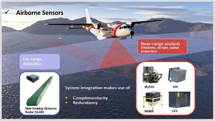
A typical mission system suite encompasses a customized set of sensors and auxiliary mission system components. This includes units for sensing, processing and communication. Mission system control.
SLAR - Far Range detection of Oil Spills is usually performed by Side-looking Airborne Radar (SLAR) which is a cloud-penetrating X radar technique of real aperture type. Aircraft coverage in a mission means a real capability of 25.000 sq. Km per flight hour in normal conditions.
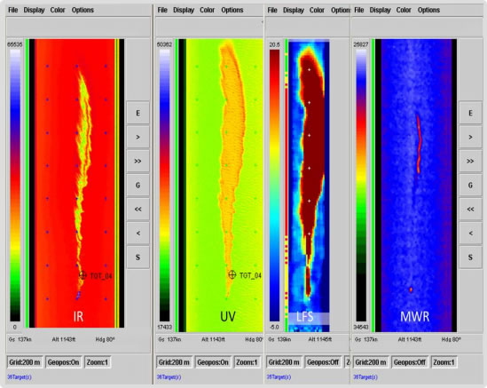
EO / IR devices are used for identification and documentation during day and night. The EO/IR system can be slaved o sensors like the Surveillance Radar or the Direction Finder. All data are recorded in the MEDUSA network on board and on-line display to operator. A 360º free rotatable and gyro stabilized turret contains cameras delivering vídeo data from the infrared and visible spectrum. The EO/IR system allows a precise search in narrow field of view.
VIS Line Scanner - VLS, is the first step as quantification tools for airborne remote sensing applications on airbone maritime surveillance. In maritime surveillance, system is ideal for acquisition of highly resolved geo-referenced Red/Green/Blue composite images. These images can be used for documentation and for more exact volume estimations based on oil appearance codes.
IR/UV - Mapping the extend of an oil spill established as standard tools of airborne mapping they are capable of mapping the total extent of the oil spill as well as areas of intermediate and large oil layer thickness. The sensor IR/UV Line Scanner is fully integrated with the MEDUSA mission system.
MWR - Absolute volume measurement Microwave radiometer is a six-channel across-track scanning microwave spectrometer capable of detecting and mapping oil layers exceeding a thickness of 0.05 millimeters. System range from 0.05 to 3 millimeters. The detection and quantification capability of MWRs are valuable in terms of oil spill response as the most critical areas of an oil spill are to quantified and measure thickness in the area.
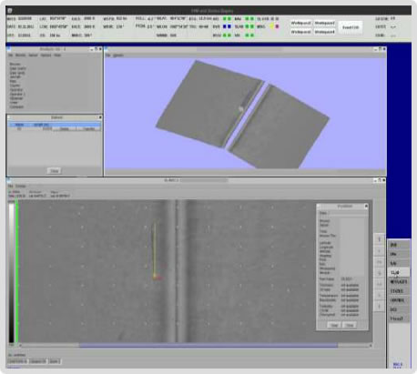
MEDUSA´s Ground Segment is the ground-based for post-processing, archiving and distribution of mission data. Based on the same post processing software installed on the airborne segment, the GS includes a redundant quick access archive system web-based GIS service which controlled access to mission data.
Data products and raw data can be easily relayed by satellite com (SATCOM) or direct data downlink to response vessels or shore-based situation centers. All data access are available in geographic information systems (GIS) which is a fundamental aspect in marine crisis management.
Operator´s - Console - Mission Control -The Man-Machine Interface (MMI) of the system can either be realized by a single Operating Console called Central Operating Console (COC), or by a configuration of multiple interchangeable single units. The Central Operating Unit (COU) which is the central mission computer creates an environment as the central part of the sensor network MEDUSA. Its tasks are:

FOTOTERRA - ALL RIGHTS RESERVED
 |
 |
 |